Leaving Certificate Geography

  • Home
  • Physical Geography
    • Skills (Maps, Photos, Graphs) >
      • Ordnance Survey Map skills
      • Aerial photographs
      • Graph skills
    • Horizons Second Edition >
      • Chapter 1 Plate Tectonics
      • Chapter 2 Folding and Faulting
      • Chapter 3 Earthquakes
      • Chapter 4 Volcanoes
      • Chapter 5 The rock cycle
      • Chapter 6 Weathering
      • Chapter 7 The Karst Landscape
      • Chapter 8 Mass Movement
      • Chapter 9 Rivers
      • Chapter 10 Coastal Studies
    • Planet and People physical chapters >
      • Plate tectonics >
        • Plate Tectonics 2
        • Plate Tectonics 3
      • Rock Formation and Cycle >
        • Rocks
        • Rock types and their formation
        • Rock Cycle
        • Rock Cycle 2
        • The Rock Cycle 3
        • Rock Landscapes: Limestone
        • Intrusive and Extrusive volcanic landforms
        • Human interaction with the rock cycle
        • Tara Mines case study
      • Folding and Faulting
      • Weathering and Erosion
      • River processes and features
      • Glaciation
      • Coastal Studies >
        • Coastal Studies Ms. Carr
  • Regional Geography
    • Horizons Regional Chapters >
      • Chapter 22 Concept of a region
      • Chapter 23 The Western Region
      • Chapter 24 The Greater Dublin Area
      • Chapter 25 The Paris Basin
      • Mezzogiorno: Peripheral European region
      • Subcontinental India
    • Planet and People Regional Chapters >
      • Regional Geography Outline
      • Definition of Regions
      • Ireland: The Greater Dublin Region - Core
      • West of Ireland - Ms. Carr
      • The West of Ireland : Peripheral Region
      • Core region: Paris Basin
      • European Regions (Core Periphery) >
        • Paris Basin: Ms. Carr
        • Mezzogiorno - peripheral region
        • Mezzogiorno: European Peripheral Region
      • Subcontinental Region: India >
        • Introduction
        • India: Powerpoint
        • India: Secondary Activities
        • India: Tertiary Activities
        • India: Ms. Carr
      • EU enlargement
  • Elective: Human Environment
    • Folens: Human Elective >
      • Chapter One: Populations
      • Chapter 2 Human development and overpopulation
      • Chapter 3 The dynamics of settlement
      • Chapter 4 Migration
      • Chapter 5 Urban problems
      • Chapter 6 Urban settlement and planning issues
    • Planet and People: Human Elective >
      • Chapter 1: Population Studies >
        • Population test
      • Chapter 2 Overpopulation in Sudan >
        • Overpopulation question
        • Overpopulation and Resources
      • Chapter 3: Migration >
        • Migration Test
        • Student presentations
        • Student Presentations 2
      • Chapter 4 Settlement >
        • Settlement Patterns
        • Student work
        • Student work 2
      • Urban Sprawl-Introduction
      • Chaper 5 Three urban land use models >
        • Chapter 5: Land use change
      • Chapter 6 Urban problems in developed world cities
      • Chapter 7 Heritage Issues & Environmental Issues
      • Chapter 8 Urban planning strategies in Ireland >
        • Chapter 9 Developing world cities / counter-urbanisation
  • Culture and Identity (Hons)
    • Physical indicators of population
    • Cultural indicators of population
    • Nationality and Nation states
    • Case study: Switzerland
  • Geoecology (Hons)
    • Soils
    • Aridisoils
    • Brown earth soils
    • Latosols - Tropical rainforest soil
    • Soil Formation
    • Soil erosion - human activities
    • Soil erosion - preventative methods
    • Biome: Tropical rainforest
  • Field Investigation
    • 2013 field study
  • Exam and Papers
    • Leaving Cert Exam
    • Honours Paper
    • Ordinary Paper
    • What do I study?
  • Revision Centre
    • Physical Revision >
      • Physical Powerpoints
      • Plate tectonic questions
      • Volcano & Earthquake questions
      • Rock revision
      • River Revision
      • Glaciation Revision
    • Regional Revision >
      • Regional Powerpoints
      • EU expansion revision
      • European Regional Revision
    • Elective Revision >
      • Human Elective Powerpoints
      • Economic short questions (H&O)
    • Geoecology Option >
      • Geoecology Powerpoints
      • Geoecology questions
    • Sample Answers >
      • Sample Answers Outline
      • Physical: Sample Answers >
        • Waterfall: River Landform
        • Delta: River Landform
        • Cirques: Glacial landform
        • Drumlin: Glacial landform
        • Cave,Arch,Stack,Stump: Coastal landform
        • Beaches: Coastal landform
        • Isostatic and Eustatic Processes
        • Human control of natural processes
        • Impact of Flood Control
        • Impact of Coastal Management
        • Landform in a Karst landscape
        • Weathering and Erosion
      • Regional: Sample Answers >
        • Regions are areas defined by one or more criteria (two discussed)
        • Agriculture in Irish region influenced by factors
        • Development of agriculture in Mezzo influenced by factors
        • Development of agriculture in Paris Basin influenced by factors
        • Development of secondary activities in a Core Region
        • Industry in The Greater Dublin Area
        • The Gaeltacht
        • Climatic Region: The Cool Temperate Oceanic Climate
        • Tertiary activities in the Paris Basin
        • Two EU policies and their impact
        • EU expansion and the impact on a member state
        • The defining role of Culture (India)
        • Urban Growth : Kolkata, India
        • Growth of an urban area Paris
        • Culture defining a region - India -outline
      • Elective: Sample Answers >
        • Migration
        • Overpopulation
        • Three Urban Models
        • Geoecology: Sample Essays >
          • Soil Formation
          • Characteristics of soil
          • How human activities can accelerate soil erosion
          • Natural processes and soil
          • Tropical rainforest biome
          • Human interaction with a biome
        • Urban problems and solutions
        • Map work: Location of a Town
      • Swapped powerpoints
  • General Information
    • Geography at Leaving Cert level

Beaches - feature of Coastal deposition

Beaches are features of deposition found in coastal areas between high and low tide.  They are generally found in areas where there is an inlet or sheltered area, between headlands or a change in the coastline which causes sediment to be trapped and build up.  If a beach is found in a bay it is called a bay head beach.

Beaches are areas of sand, shingle and larger stones.  They are created by a number of factors:

Destructive waves are waves that create coastal features.  The swash is more powerful than the backwash and material is pushed up the coastline.  As the wave flows back down the coastline much of the water percolates down through the sand and the backwash does not have enough energy to remove much material.

Longshore drift is the movement of material along the coastline in a zig-zag manner.  The waves approach the beach at an angle but return in a straight manner and sediment is carried along by this process until it is interrupted by a headland or change in coastline.

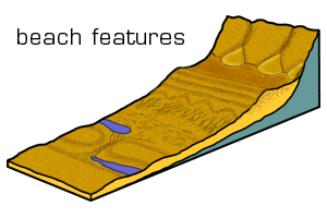
Beaches can be divided into three main areas:

Foreshore: the part of the beach closest to the water.  Here features such as runnels and ridges may be found.  These are long rises and depressions in the sand parallel to the coastline and formed by constructive waves breaking.

The middle shore is the part of the beach where ripple marks are found.  These are gentle lines in the sand created by the swash.  Beach cusps may also be found here.  These are crescent shaped hollows in the beach where you tend to find the shingle changes to softer sand.  Berms are long, narrow ridges of stones and shingles which tend to mark the dividing point of the middle shore and backshore.  This tends to be the area that the waves reach when the tide is in.

Finally the backshore is the area where the storm beach, sand dunes and cliff face are found.  A storm beach is the area where strong waves have moved larger pieces of material up the beach.   Some beaches have natural or man-made dunes (mounds of sand usually anchored by marram grass) and some have boulder clay or rocky cliffs marking the end of the beach.

Examples of beaches include:

·         Dollymount Strand, Dublin.

·         Curracloe Beach, Wexford

·         Bondi Beach, Sydney, Australia.

When drawing a diagram of a beach, try to show the location and shape of each of the features mentioned above.  Use neat arrows or a key system.  Frame and title your diagram.

Picture
beaches_feed.docx
File Size: 37 kb
File Type: docx
Download File

Powered by Create your own unique website with customizable templates.