River erosion
A waterfall is a feature of erosion found in the youth stage of a river.
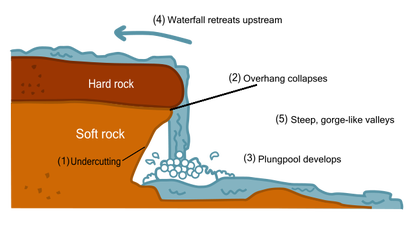
Waterfalls are found in areas with bands of hard and soft rock (otherwise known as resistant and less resistant rocks). The hard rock takes longer to erode than the soft rock (differential erosion) so the river erodes the land at different rates. The river erodes the soft rock by the main processes of erosion including Hydraulic Action (the force and power of the moving river) and Abrasion (the scraping of the load against the bed and banks).
At first a small notch is created in the bedrock. This is a groove or dip in the soft rock. The notch may only be a few inches of a drop yet it increases the speed of the river falling over the edge. This encourages the river to erode vertically (downcutting) into the soft rock creating a vertical drop.
Over time the waterfall deepens as the soft rock is continuously eroded. At the base of a waterfall a rounded pool is found. This is called a plunge pool. The force of the falling water causes the water to swirl in the pool in a movement called eddying.
As the water falls the hydraulic action may cause water to splash back against the back wall causing further erosion. This causes undercutting of the back wall. Finally the overhang of hard rock is unstable and unsupported due to undercutting. It collapses and the rocks fall into the plunge pool.
Waterfalls continue to erode backwards in a process called headward erosion. This is when the hard and soft rock is all worn away and the river returns to its original slope.
There are two main types of waterfall:
Cataracts are large vertical falls of water and cascades are waterfalls that fall over a series of smaller steps or drops.
· 3 examples (one Irish)
· Draw, colour, label diagram
A waterfall is a feature of erosion found in the youth stage of a river.
Waterfalls are found in areas with bands of hard and soft rock (otherwise known as resistant and less resistant rocks). The hard rock takes longer to erode than the soft rock (differential erosion) so the river erodes the land at different rates. The river erodes the soft rock by the main processes of erosion including Hydraulic Action (the force and power of the moving river) and Abrasion (the scraping of the load against the bed and banks).
At first a small notch is created in the bedrock. This is a groove or dip in the soft rock. The notch may only be a few inches of a drop yet it increases the speed of the river falling over the edge. This encourages the river to erode vertically (downcutting) into the soft rock creating a vertical drop.
Over time the waterfall deepens as the soft rock is continuously eroded. At the base of a waterfall a rounded pool is found. This is called a plunge pool. The force of the falling water causes the water to swirl in the pool in a movement called eddying.
As the water falls the hydraulic action may cause water to splash back against the back wall causing further erosion. This causes undercutting of the back wall. Finally the overhang of hard rock is unstable and unsupported due to undercutting. It collapses and the rocks fall into the plunge pool.
Waterfalls continue to erode backwards in a process called headward erosion. This is when the hard and soft rock is all worn away and the river returns to its original slope.
There are two main types of waterfall:
Cataracts are large vertical falls of water and cascades are waterfalls that fall over a series of smaller steps or drops.
· 3 examples (one Irish)
· Draw, colour, label diagram
| waterfall.docx |
