Leaving Certificate Geography

  • Home
  • Physical Geography
    • Skills (Maps, Photos, Graphs) >
      • Ordnance Survey Map skills
      • Aerial photographs
      • Graph skills
    • Horizons Second Edition >
      • Chapter 1 Plate Tectonics
      • Chapter 2 Folding and Faulting
      • Chapter 3 Earthquakes
      • Chapter 4 Volcanoes
      • Chapter 5 The rock cycle
      • Chapter 6 Weathering
      • Chapter 7 The Karst Landscape
      • Chapter 8 Mass Movement
      • Chapter 9 Rivers
      • Chapter 10 Coastal Studies
    • Planet and People physical chapters >
      • Plate tectonics >
        • Plate Tectonics 2
        • Plate Tectonics 3
      • Rock Formation and Cycle >
        • Rocks
        • Rock types and their formation
        • Rock Cycle
        • Rock Cycle 2
        • The Rock Cycle 3
        • Rock Landscapes: Limestone
        • Intrusive and Extrusive volcanic landforms
        • Human interaction with the rock cycle
        • Tara Mines case study
      • Folding and Faulting
      • Weathering and Erosion
      • River processes and features
      • Glaciation
      • Coastal Studies >
        • Coastal Studies Ms. Carr
  • Regional Geography
    • Horizons Regional Chapters >
      • Chapter 22 Concept of a region
      • Chapter 23 The Western Region
      • Chapter 24 The Greater Dublin Area
      • Chapter 25 The Paris Basin
      • Mezzogiorno: Peripheral European region
      • Subcontinental India
    • Planet and People Regional Chapters >
      • Regional Geography Outline
      • Definition of Regions
      • Ireland: The Greater Dublin Region - Core
      • West of Ireland - Ms. Carr
      • The West of Ireland : Peripheral Region
      • Core region: Paris Basin
      • European Regions (Core Periphery) >
        • Paris Basin: Ms. Carr
        • Mezzogiorno - peripheral region
        • Mezzogiorno: European Peripheral Region
      • Subcontinental Region: India >
        • Introduction
        • India: Powerpoint
        • India: Secondary Activities
        • India: Tertiary Activities
        • India: Ms. Carr
      • EU enlargement
  • Elective: Human Environment
    • Folens: Human Elective >
      • Chapter One: Populations
      • Chapter 2 Human development and overpopulation
      • Chapter 3 The dynamics of settlement
      • Chapter 4 Migration
      • Chapter 5 Urban problems
      • Chapter 6 Urban settlement and planning issues
    • Planet and People: Human Elective >
      • Chapter 1: Population Studies >
        • Population test
      • Chapter 2 Overpopulation in Sudan >
        • Overpopulation question
        • Overpopulation and Resources
      • Chapter 3: Migration >
        • Migration Test
        • Student presentations
        • Student Presentations 2
      • Chapter 4 Settlement >
        • Settlement Patterns
        • Student work
        • Student work 2
      • Urban Sprawl-Introduction
      • Chaper 5 Three urban land use models >
        • Chapter 5: Land use change
      • Chapter 6 Urban problems in developed world cities
      • Chapter 7 Heritage Issues & Environmental Issues
      • Chapter 8 Urban planning strategies in Ireland >
        • Chapter 9 Developing world cities / counter-urbanisation
  • Culture and Identity (Hons)
    • Physical indicators of population
    • Cultural indicators of population
    • Nationality and Nation states
    • Case study: Switzerland
  • Geoecology (Hons)
    • Soils
    • Aridisoils
    • Brown earth soils
    • Latosols - Tropical rainforest soil
    • Soil Formation
    • Soil erosion - human activities
    • Soil erosion - preventative methods
    • Biome: Tropical rainforest
  • Field Investigation
    • 2013 field study
  • Exam and Papers
    • Leaving Cert Exam
    • Honours Paper
    • Ordinary Paper
    • What do I study?
  • Revision Centre
    • Physical Revision >
      • Physical Powerpoints
      • Plate tectonic questions
      • Volcano & Earthquake questions
      • Rock revision
      • River Revision
      • Glaciation Revision
    • Regional Revision >
      • Regional Powerpoints
      • EU expansion revision
      • European Regional Revision
    • Elective Revision >
      • Human Elective Powerpoints
      • Economic short questions (H&O)
    • Geoecology Option >
      • Geoecology Powerpoints
      • Geoecology questions
    • Sample Answers >
      • Sample Answers Outline
      • Physical: Sample Answers >
        • Waterfall: River Landform
        • Delta: River Landform
        • Cirques: Glacial landform
        • Drumlin: Glacial landform
        • Cave,Arch,Stack,Stump: Coastal landform
        • Beaches: Coastal landform
        • Isostatic and Eustatic Processes
        • Human control of natural processes
        • Impact of Flood Control
        • Impact of Coastal Management
        • Landform in a Karst landscape
        • Weathering and Erosion
      • Regional: Sample Answers >
        • Regions are areas defined by one or more criteria (two discussed)
        • Agriculture in Irish region influenced by factors
        • Development of agriculture in Mezzo influenced by factors
        • Development of agriculture in Paris Basin influenced by factors
        • Development of secondary activities in a Core Region
        • Industry in The Greater Dublin Area
        • The Gaeltacht
        • Climatic Region: The Cool Temperate Oceanic Climate
        • Tertiary activities in the Paris Basin
        • Two EU policies and their impact
        • EU expansion and the impact on a member state
        • The defining role of Culture (India)
        • Urban Growth : Kolkata, India
        • Growth of an urban area Paris
        • Culture defining a region - India -outline
      • Elective: Sample Answers >
        • Migration
        • Overpopulation
        • Three Urban Models
        • Geoecology: Sample Essays >
          • Soil Formation
          • Characteristics of soil
          • How human activities can accelerate soil erosion
          • Natural processes and soil
          • Tropical rainforest biome
          • Human interaction with a biome
        • Urban problems and solutions
        • Map work: Location of a Town
      • Swapped powerpoints
  • General Information
    • Geography at Leaving Cert level

With reference to the Irish landscape, examine the processes which have influenced the development of any landform in a karst region. [30m]
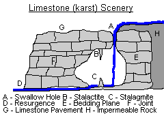
SWALLOW HOLE

A swallow hole is a funnel shaped point on the river bed down through which a stream or river flows underground. It is also referred to as a sink hole.  Examples of this landform are found in the karst region of the Burren in Co. Clare. One example is found at Poll na gColm. 
A karst region is an area of bare limestone rock that is being worn down by chemical weathering.
Distinctive landforms form including the swallow hole.

FORMATION

Swallow holes form on the limestone bedrock of a river. The constant flow of water makes the limestone vulnerable to weathering. This is because Limestone is a permeable rock. This means that water can seep or travel down through it. This is because it has weaknesses that allow water through them. 
These include;
Joints – these are vertical cracks in the limestone rock. Water will move down through them.
Bedding Planes – these are horizontal weaknesses that separate one limestone rock layer from another.

It is because of these weaknesses that water can move down from the surface through several underground layers. Limestone is vulnerable to the chemical weathering process of carbonation.  This is caused by carbonic acid dissolving the cementing agent (compound agent) of the limestone. This cementing agent is called calcite.  The calcite will be dissolved into a solution called calcium bicarbonate. It will be carried away in water.  The process of carbonation will be ongoing on the riverbed because of the constant flow of water.  Over time, the joints reaching the riverbed will be widened. Below the surface, the bedding planes will also be widened. More and more water will be lost from the surface stream.  As more water flows underground, the joints and bedding planes will also be widened by the impact of rover erosion processes such as hydraulic action (the power of the flowing water) and abrasion (the impact of the stream’s load hitting against the sides of the joints and bedding planes).
Eventually the entire flow of water in the stream will disappear down the enlarged joints and bedding planes which have become a swallow hole. The overlying riverbed dries up to form a dry valley. The stream will flow underground and may emerge at a lower level as a spring.


Picture
Picture
Powered by Create your own unique website with customizable templates.